How to start with SBAS mode?
 Brief Introduction
A Satellite Based Augmentation System (SBAS) is a wide area differential Global Navigation Satellite System signal augmentation system which uses a number of geostationary satellites, able to cover vast areas, to broadcast primary GNSS data which has been provided with ranging, integrity and correction information by a network of SBAS ground stations. While the primary purpose of SBAS is to provide integrity assurance, use of the system also increases the accuracy and reduces position errors to less than 1 meter.
Compared with general GNSS positioning, SBAS is capable of covering vast areas, increasing the accuracy and reducing position errors to less than 1m. At present, the world's leading powers have also developed their own satellite navigation systems, such as the WAAS system of the United States, the EGNOSS of the European Union, the MSAS of Japan, the GAGAN of India, the SDCM of Russia ,and the BDSBAS of China under development.
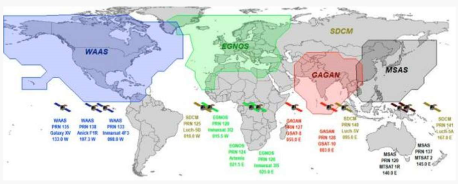
SBAS Global Distribution Map
Working Principle
The satellite-based augmentation system is composed of four parts: space constellation, ground control station, operation and maintenance station and user. Users can broadcast a variety of correction information such as ephemeric error, satellite clock error, ionospheric delay, etc., through the geostationary orbit (GEO) satellite carrying satellite navigation augmented signal repeater to improve the positioning accuracy of the original satellite navigation system.
The navigation satellite is monitored by a widely distributed differential stations (with known positions), and the original positioning data (pseudo range, carrier phase observation values, etc.) are obtained and sent to the central processing facility (main control station). Then GNSS data from satellites are compared against the precisely documented locations of each land-based monitor. Any discrepancy is determined to be an error. Error corrections are sent to geostationary satellites and broadcast throughout the region.
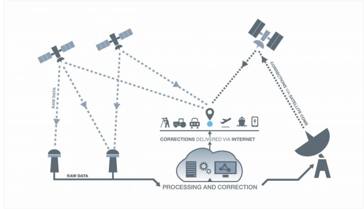
SBAS Schematic Diagram
GNSS accuracy can reach around five meters while using SBAS, users can achieve an accuracy of two meters or better. Some receivers or OEM boards can apply SBAS corrections with additional techniques to achieve sub-meter or better accuracy. Here's a step-by-step guide for you to start with SBAS mode.
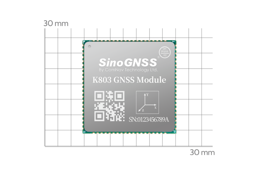
We’ll take ComNav K803 OEM module as an example. The control software is CRU, one of ComNav’s self-developed software for OEM board testing, setup, data recording, data download and information display, you can download it by free from ComNav website: More about URL

ComNav GNSS OEM Board
The default setting for SBAS is disabled. Users can send the following commands to activate SBAS mode in CRU software:
SET PVTOBSMODE SBAS | //activate SBAS mode |
SET SBASSYS MSAS/WAAS/EGNOS/GAGAN | //set SBAS satellite based on service coverage |
SAVECONFIG | //save configuration |
Tip1: To disable SBAS, send command “set pvtobsmode single”.
Tip2: If you need configure SBAS mode with your own program, we suggest to request above commands twice, in case the commands are not accepted succeed.
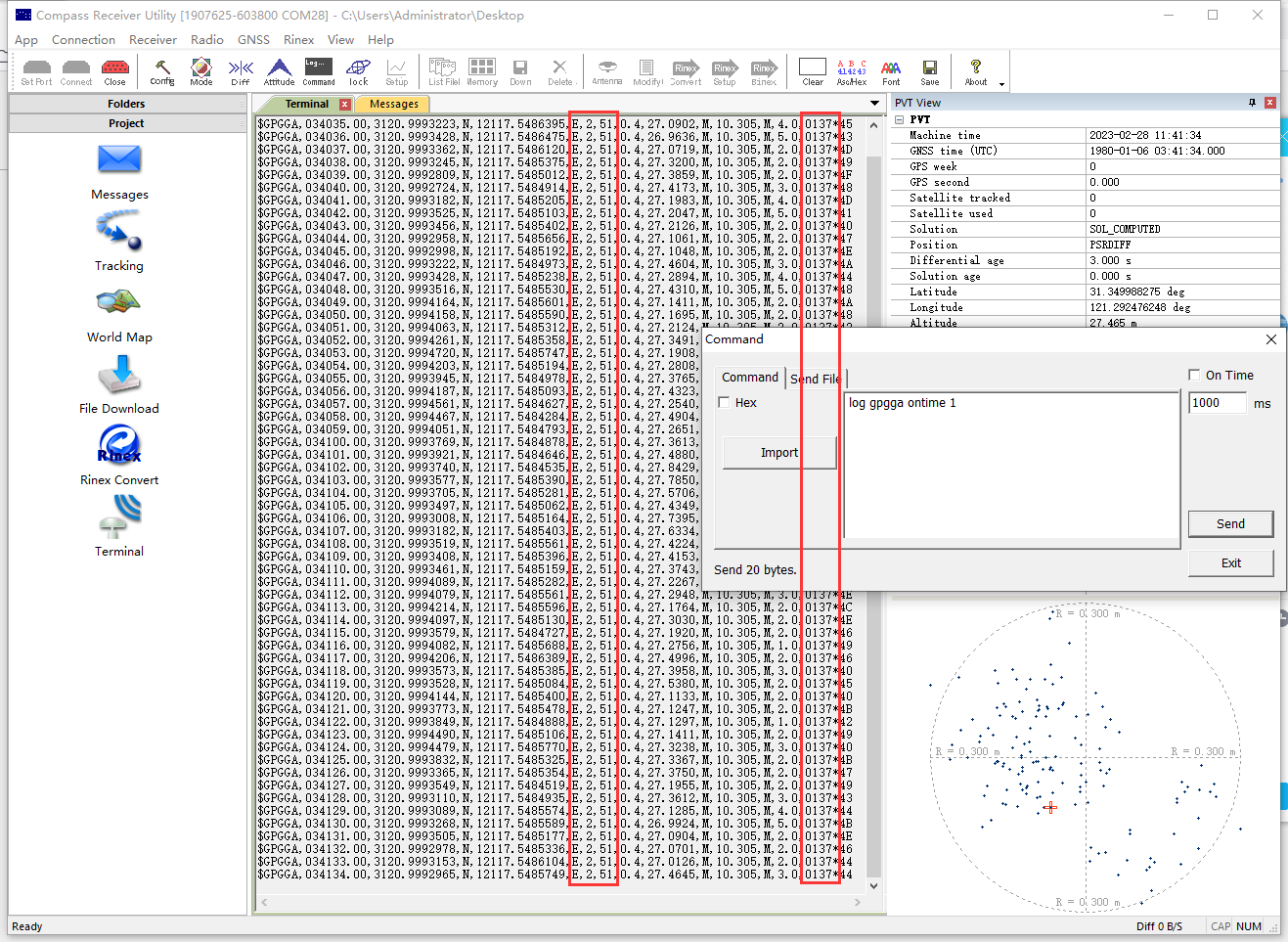
After sending above commands, normally it will take 2-5 minutes to search SBAS satellites, then the board will go into SBAS solution. You can request GPGGA message with command “log gpgga ontime 1” to check solution status. In SBAS mode, the solution status should be “2” and base ID should be SBAS satellite’s PRN.
An example of GPGGA message:
$GPGGA,015101.00,3121.0000551,N,12117.5483125,E,2,23,1.1,37.2598,M,0.000,M,02,0137*5
If it takes longer time and cannot access to SBAS mode, you need to check firstly if the configuration is successful.
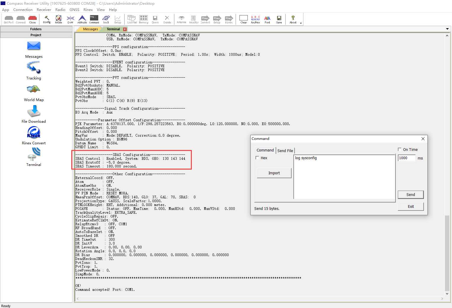
Enter “LOG SYSCONFIG” to check whether SBAS mode is enabled. Enable means SBAS enabled, and Disable means SBAS not enabled.
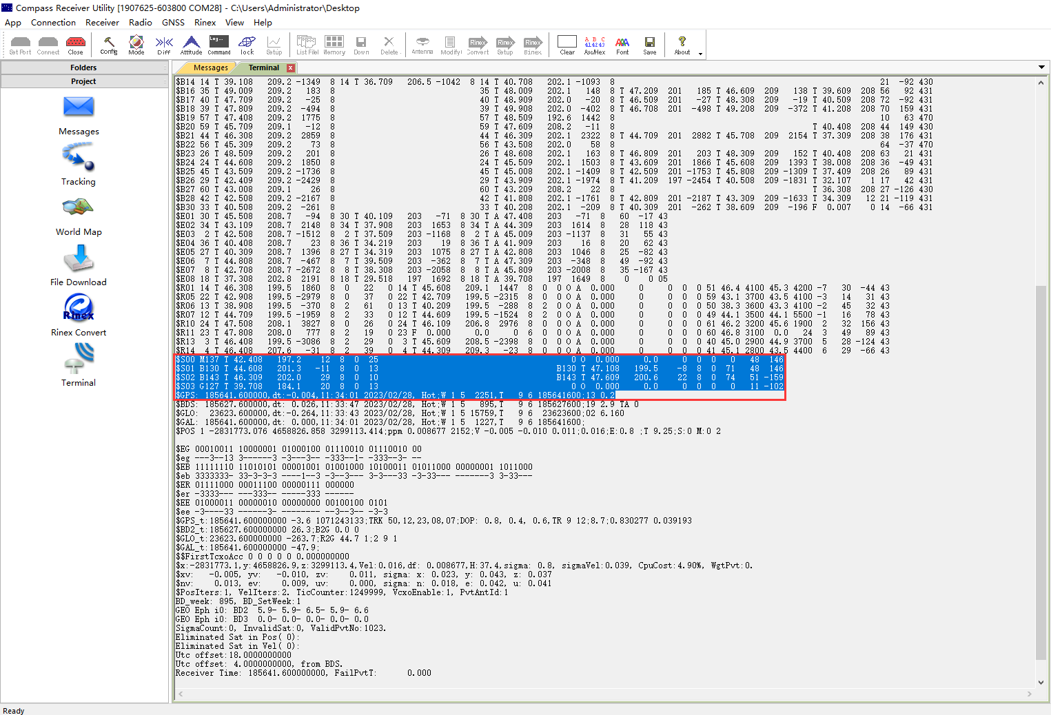
If the SBAS mode is enable, and still cannot go into SBAS mode, you can use command ”Log Testinfor” to check if the SBAS satellite is searchable. The satellites marked with S are SBAS satellites.
With brand-new SBAS engine, currently we verified in Japan-MSAS, China-BDSBAS, India-GAGAN, Europe-EGNOS. the SBAS accuracy can be very stable 0.6 horizonal.
|
|
MSAS | EGNOS |
|
|
GAGAN | BDSBAS |
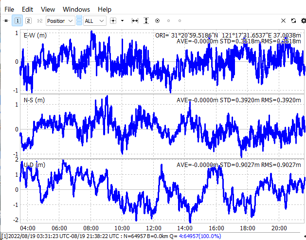
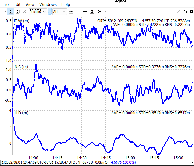
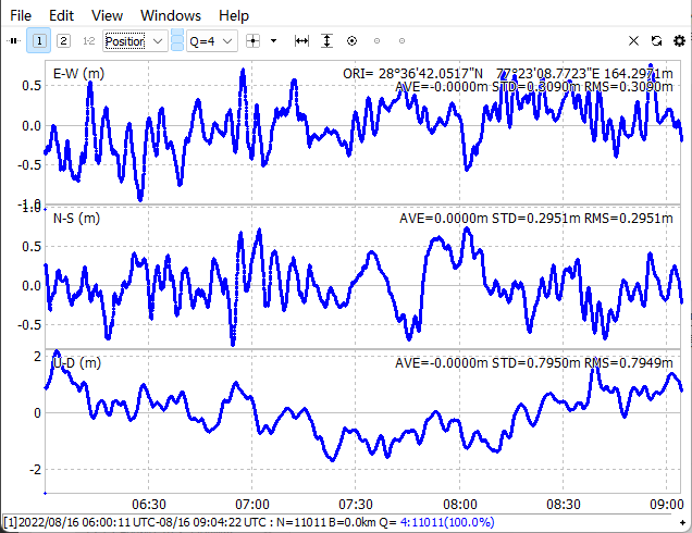
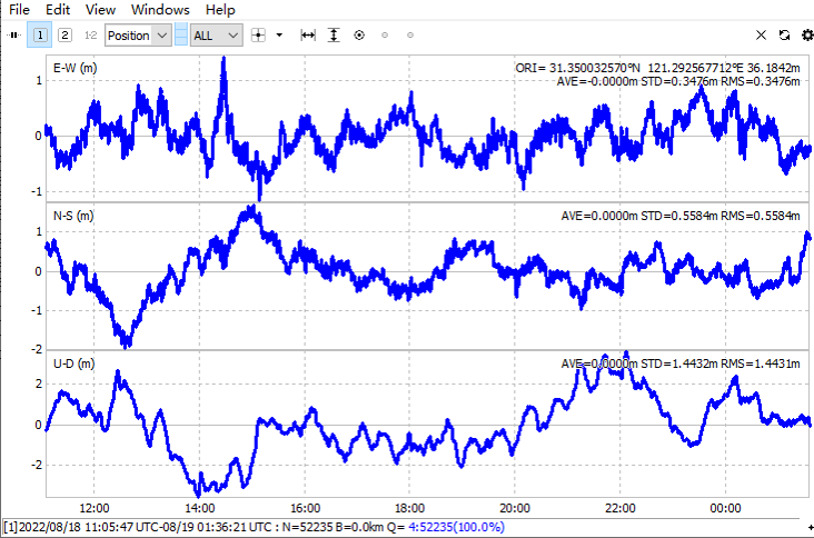
SBAS Convergence Accuracy Table
N RMS m | E RMS m | Z RMS m | |
EGNOS | 0.3276 | 0.2227 | 0.6517 |
GAGAN | 0.2951 | 0.3090 | 0.7949 |
MSAS | 0.3920 | 0.3518 | 0.9027 |
BDS | 0.5584 | 0.3476 | 1.4431 |
So far, SBAS system is widely used in industries across aerospace, geodesy, marine navigation, personnel positioning, settlement monitoring and other fields. Consequently, it performs well even in challenging situations, such as complex terrain, valleys, or areas with strict requirements for navigation. The most prominent benefit of SBAS is cost saving as it enables to location without receiving network differential.
About ComNav Technology
ComNav Technology develops and manufactures GNSS OEM boards and receivers for high precision positioning demanded applications. Its technology already been used in a wide range of applications such as surveying, construction, machine control, agriculture, intelligent transportation, precise timing, deformation monitoring, unmanned system. With a team dedicated for the GNSS technology, ComNav Technology is trying its best to supply reliable and competitive products to worldwide customers. ComNav Technology has been listed on the Shanghai Stock Exchange (Science and Technology Board), securities :ComNav Technology (Compass Navigation), Stock code: 688592.
About SinoGNSS®
SinoGNSS® is the official trademark of ComNav Technology Ltd., registered in People's Republic of China, EU, USA and Canada. All other trademarks are the property of their respective owners.